|
begun by our friend Jeff Couch, now deceased
and edited
by John Fuhring
May, 2010 Please note that this is a story that contains historical, educational, technical and biographical elements. The Appendix contains a lot of personal opinion and observations that you do not have to agree with. More than anything else, this story does not pretend to be a scholarly treatise. The
early beginnings of
the Ranch:
According to available sources, the Careaga brothers, mentioned
in this story, were descended
from
a Spanish nobleman of medieval Castile. At some time after
the
conquest of Mexico, the King of Spain sent a Careaga to the New
World
to make his home in Mexico. It is Mexico where the ancestral
family has lived these many generations and from there that descendants
of the family radiated. A
scion of the Mexican Careaga family was the famous soldier, Satornino
Careaga who, at the age of 17,was ordered from his home in Mexico
to the city of Monterey in Alto California as
a junior officer to serve under Captain
Muňoz. Señor Careaga was charged with the
protection of
the
San
Jose Mission and rose to the rank of Colonel. Colonel Careaga had at least two sons, Ramon F. Careaga, and Juan B. Careaga. At some time after leaving their parent's home, Ramon and Juan formed a partnership and together with a man named Daniel Harris (distantly related to Juan by marriage), bought roughly 18,000 acres of land from the famous De la Guerra family between what is now Los Alamos and Orcutt. Later, in a land partition, Harris settled for 7,500 acres to the south of highway 135 near Harris Grade (and now belonging, in part, to Betteravia Farms) and the brothers kept the remaining 10,500 acres to the north. Around 1895, Ramon discovered an outcrop of oil shale on his portion of the ranch. By the way, oil shale, high in asphalt and found in the diatomaceous Sisquoc Formation, is common in this region. Decades before the oil strikes of the early 20th Century, the shale was mined by underground tunneling into the formation. To extract the oil from the shale, the rock was heated in large vats and the resulting tarry crude was sold for steamship fuel and to the City of San Francisco as asphalt for paving the streets. In 1900 a wealthy and influential lawyer by the name of John D. Bicknell, together with other men of business and investors, organized the Western Union Oil company (no affiliation with Western Union Telegraph). Impressed by the findings of oil shale and reportedly on the advice of the famous Los Angeles water engineer, William Mulholland, Western Union Oil attempted to buy the entire 10,500 acres from the Careaga brothers, but had to settle for an agreement whereby they paid them 10% from the sale of any oil they produced on the ranch. 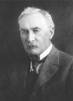 William Mulholland, (in)famous for bringing Owens Valley water to L.A. enabling it to grow. There is precious little evidence that Mulholland was involved with the Western Union Oil Co., but there is at least one historical reference to him. After drilling two dry holes on the south side of Graciosa Ridge south of the present town of Orcutt and on Ramon's property, Western Union Oil's Careaga No. 3 came in sometime in October of 1901 and it was a "gusher," producing about 150 barrels a day using only well-head pressure. Incidentally, No. 3 did not stop producing until 1947. Careaga Number 3 was the first commercially viable oil discovery in the Santa Maria area and it attracted a lot of attention. Soon oil drillers from all over the U.S. converged on the area and opened new wells, including one of the biggest wells of all time, "Old Maud" (10,000 barrels a day - yes, a day - for several months). For a time the south end of the Santa Maria Valley was producing the greatest volume of oil of any region in the world and all this oil made the Santa Maria Valley world famous. It didn't take too long for another oil company with a similar sounding name, the Union Oil Company of California (later Unical), to become aware of the commercial possibilities of the rich petroleum reserves likely to be found on the Careaga Ranch and soon they were sinking wells on Graciosa Ridge too (*A1). With oil wealth now assured, the Careaga's held a huge barbecue where four of their finest cattle were served to hundreds of guests. This unprecedented feast, cooked over coals from the magnificent Red Oak Wood that grows in abundance on the ranch, may well have established the fine tradition of the justifiably world famous "Santa Maria Barbecue" which has and will far outlive the Careaga Ranch's petroleum deposits. When you dine at one of our fine old steakhouses or up at "The Union Oil Picnic Grounds" with fine meat cooked over local Red Oak and complete with pinquito beans grown in our area, you might reflect on when and how all this started. Already rich, Juan Careaga died suddenly and without a will while in Santa Barbara in 1904. He had lived with Daniel Harris' wife's mother (Rose Castro-Figueroa) "in sin" (as it was called in those days) for several years after her legal husband, Jesus Figueroa, deserted her. While living together, Rose gave birth to a daughter, Eloisa. Juan and Rose became legally married after a divorce from Figueroa was granted, but Eloisa's status was never formalized. As mentioned, Juan died intestate so court battles raged especially regarding Eloisa's share of the estate. The other siblings tried to pretend that Eloisa was not Juan's daughter, but that she was actually Jesus Figueroa's daughter (since she was born while her mother was still legally married to Figueroa). Of course this was absurd and so, in October of 1905, the courts declared that Eloisa was indeed Juan's natural daughter by law and entitled to 1/4 of his estate. After Juan died, Ramon attempted to assert that Juan's oil lands were to go to him by prior agreement. In December of 1905 a settlement was reached with Juan's heirs to the effect that Ramon would give 1/8 interest of the oil on his lands to each of the four heirs and they in turn would grant him 1/2 interest of the oil on their lands. In other words, half of the oil on Ramon's land went to Juan's heirs and half of all the oil on their lands went to Ramon in keeping with the original agreement between the brothers. The remainder of Juan's part of the Ranch was divided between the four heirs equally now that Juan's natural daughter's case was settled. Ramon Careaga was married to Maria Antonia Bonevantur and they had 11 children. Sometime in the early 20th Century, Ramon Careaga and his wife leased out their share of the ranch and oil lands and retired to San Jose where he died in 1914. Evidently the distribution of inheritance went smoothly after the passing of Ramon and Maria. Nothing lasts forever and with the passing of time and the brothers, the Ranch split up, making way for other more recent and just as wonderful happenings on the land, the land which always endures. The
Ranch today:
No one surnamed Careaga lives on any part of the old ranch
today,
however the recently deceased Mr. Richard Henry Dana owned a section of the
original Careaga Ranch and he was related to the Careaga's. By
the way, Mr. Dana was named after the author of “Two years
before
the
mast" although he is more likely descended from William Dana,
who was a fourth cousin to the more famous Richard Dana.
William was a seafaring captain and builder of the historic
Dana Adobe in Nipomo.Until the 1990s, Toni Suffert and Stanley Carr (great grandson to Ramon Careaga) owned portions of the old ranch. Stanly had a contract with the State of California to repair shoes and so he set up a small manufacturing facility on the ranch. As you drive onto the old ranch road, past Richard Dana's turnoff and a quarter mile past the electric gate with the combination lock, just before you enter the gate for Kick On Ranch, on the right you will pass a green shed that Stanley used for his repair shop. In addition to his land holdings, Stanley Carr owned the landmark Carr’s Boots in Santa Maria. Today, two sections of the old ranch are owned by, Lindsey & Jimmy Reed-Dominguez and Steve & Cindy Lyons. These owners are working with the Santa Barbara Land Trust to establish an easement that would protect their portions of the old ranch from future development. You can read more about it at http://www.sblandtrust.org/careagacanyon.html. Oil activity on the old ranch today is just a ghost of its former self. Nearly all the old wells are now abandoned and the hills are covered with roads and graded spots where the old rigs once were. 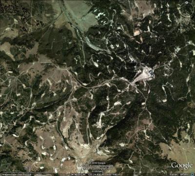 Northern section of the old Careaga Ranch. Scars on the land from past oil activity seen from space. Ironically, every now and again a new well is drilled and new oil is produced. A new well is now located just a few hundred yards north from the old entrance to the ranch. Much of the old northern section of the ranch is now owned by various oil companies who maintain the few wells, pipelines and tanks that remain in operation, but the people working out there are just a tiny fraction of the numbers who were once employed. (see John's Rant No 2.) By the way, it appears that the Careaga Family Trust still has mineral rights to the land and they may place new oil wells and access to them anywhere they choose. Today there are many wonderful things always happening on what was once the Careaga Ranch. These are things that will someday be put right along side the storied happings of "the good old days" of the early 20th Century. Having said that, it is beyond the scope of this little page to detail all the wonderful things that the present holders of this land have so generously done for their friends. Those of us who know and participate in those wonderful activities realize how privileged we are and we know that "the good old days" are, by no means, behind us. Indeed, we know for ourselves that "the good old days" were never as good as the days are today for the owners and their friends. The spirit of "La Graciosa" is as vital today as it has ever been --- and more so. Travel
during the
era of the Careaga Ranch:
 1899 railroad map of California Pacific Coast Railway in red. In the late 19th and early 20th centuries, public transportation was by ship, stage coach or railroad. For speed and comfort, the railroad was the only way to travel overland and for rail transportation, our area was served by the now extinct Pacific Coast Railway that began operations in 1882. Up until about 1902, when spur lines were established to the Southern Pacific line, travelers heading south would disembark from a packet steamer at Avila Beach. At the Hardford Wharf there at Avila, they'd catch the Pacific Coast Railway train going first to landlocked San Luis Obispo and there, south on to the end of the tracks at Los Olivos. The
Pacific
Coast Railway
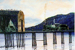 "Starting Point" Engine
105 picking up
freight and passengers from steamships anchored off Avila Beach.
The Hardford wharf is still there although it lost several hundred feet
to a storm years ago.
On the journey south, the train would stop at all the stations along the way including Santa Maria, Lakeview, Graciosa Station (a mile south of where Old Town Orcutt is today), proceed to Careaga Station (on tracks just a few yards north of present day highway 135), stop at the Los Alamos Station (many of the buildings are still there) and finally on to Los Olivos. The engineers of the Pacific Coast Railway used to make a joke about the southern end of their narrow gauge rail line as they were heading into Los Alamos and Los Olivos. By the time they reached Los Alamos they were "Lost Almost" and at Los Olivos they said they were "Lost Altogether." The
Pacific
Coast
Railway
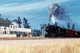
"The
End of
the
Line"
Depicted
here is PCR Engine
Number 106 pulling one
of the last trains into Mattie's Tavern and Hotel at Los Olivos (circa
1930). The only remaining
artifact in this picture is the Tavern which, to this day, continues in Mattie's
tradition of
fine food and hospitality.
At the Los Olivos Station, south bound passengers would disembark because this was indeed the end of the line. In early times, this train carried many Danish immigrants who got off at Los Olivos, but who continued on a few more miles by foot or by coach to the land adjacent to the Old Santa Ynez Mission where they founded and expanded the "more Danish than Denmark" community of Solvang (*A2). Those passengers going on to Santa Barbara and points south would dine at Mr. Mattie's Tavern and spend the night at Mrs. Mattei’s Hotel. The story is told that Mrs. Mattei was a temperance type, but Mr. Mattei (being the good innkeeper he was) liked to party. She would not have "Demon Rum" under her roof, so the tavern part of Mattei's had to be built separate from the hotel. The following morning, after enjoying the hospitality provided by Mr. & Mrs. Mattei, the travelers would board a horse drawn stagecoach for the arduous trip to Santa Barbara with a lunch stop at the famous Cold Springs Tavern. From there they would cross over the San Marcus Pass and on down into Santa Barbara. The slow moving coaches would sometimes be robbed at gunpoint by lurking banditos thus making the trip just that much more adventurous (*A3). Those continuing even further south would spend the next night in Santa Barbara. At Santa Barbara travelers would either continue on by stage to San Buenaventura (AKA, Ventura) and on to Los Angeles or else board a ship. Ironically, For those traveling by stagecoach through Santa Barbara, ocean tides were important because part of the journey was along the beach. The firmer wet sands of low tide had to be exposed or the wheels would sink in and the coach would get stuck. According to accounts, passengers were frequently required to help push the stage through sections where the sand was too soft to support the narrow rims of the coach wheels. The
Railway in later years:
There are visible reminders of the rail and stagecoach era
to
be seen on portions of the old Careaga Ranch to this day.
As
you turn on to the ranch and head north from highway 135, you soon
cross the old
Pacific Coast Railway right-of-way and a line of poles supporting power
lines. The power lines were established along the rail line
and
before the highway was built and that is why they are set so far back
off the highway. When the railway was abandoned in the early
1900’s, many of the old railroad ties
were then used as fence posts throughout the ranch. To this
very
day some of those old ties, with spikes still embedded in them, can be
seen as you ride around the ranch. The reason
these old
ties have
survived nearly 100 out in the weather is because they are made
of redwood. Also to be seen, off to the right of the road
(underneath the Pepper Tree), are the
remains of one of the two school houses that were on land
that Ramon Careaga had donated. The other
schoolhouse was at the town of Bicknell.The Pacific Coast Railway 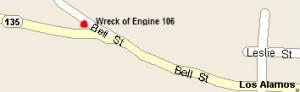 "The Wreck of Old 106" The
Pacific Coast Railway
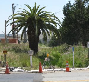 "Orcutt Station Today" This
is a view taken in the middle of Clark Avenue looking south.
The
"ditch" to the
right of the palm tree is where the tracks were and the bank above,
where the old metal buildings still are, was where Orcutt Station had
been.
 Directly
behind me can be the seen the right of way heading north toward Santa
Maria and nearby is a bronze plaque (hidden in the grass) telling about
the railway. Photos taken May 15th, 2010.
An
Oil Town on the Careaga Ranch.
On the North end of the Careaga Ranch, an oil
town sprang up almost overnight after the first gushers
came in. Bicknell was named after Western Union Oil president
John D. Bicknell, a famous lawyer and businessman from Los Angeles.
At its apex, the town boasted a population of around
1,500, a school house, a grocery store, a gas station,
a baseball diamond and
a swimming pool.The remains of the pool can still be seen to
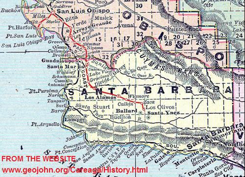
this day.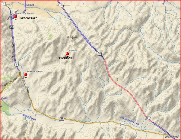 Map
showing the
location of Bicknell near the center and the approximate location
of
Graciosa
Station at
the upper left.
Further north of Bicknell was Graciosa Station located near
where
the little town of La Graciosa used to be.
The story goes that La Graciosa was started in the 1860s as a
saloon and livery stable to serve the stage coach line and that it
later grew to include a post office, stores and a school.
There
is very little researchable history of La Graciosa, but it is supposed
to be the oldest
non-native settlement in the
Santa Maria Valley. The town disappeared when the land was
bought
by the famous H.M. Newhall (of the Newhall Land and Farming Company) in
1879
and, after loosing in court, all the squatters had to leave.
Soon the houses and buildings were gone and thus
ended La
Graciosa. Today nothing
remains and nobody really knows exactly where La Graciosa was, but it
was probably where the Orcutt Expressway-Highway 1 interchange is today.
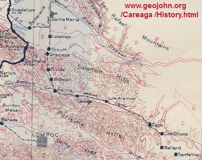 1915 railroad map showing Graciosa and Bicknell Stations By 1904, the area around Graciosa Station was a beehive of activity due to all the rich oil strikes nearby. Tank cars specially built to carry crude oil, freight cars and passenger cars were constantly arriving and departing, overwhelming the little station. There was a need for a reliable water supply and a big need for more space on more open terrain, so the Union Oil Company had their chief engineer lay out a new town a mile or so north of Graciosa Station. Union Oil Company president E.W. Clark named it "Orcutt" in honor of his head geologist, William W. Orcutt, with the main street of town named Clark Avenue - wouldn't you just know it. By all accounts, William Orcutt thought that naming the town after him was a little bit tacky, but the name stuck as it did to another oil town named for him in Colorado. 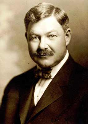
William
Warren
Orcutt
The
geologist who
revolutionized oil exploration
and the study of
the Quaternary paleontology of California. In 1901 William
Orcutt was exploring G. Allan Hancock's Rancho La Brea (now in the
heart of Los
Angeles) for oil when he discovered and later extracted fossils from
bone filled masses of very old hardened asphalt found there. These
bones turned out to be from
extinct mega fauna of California's Pleistocene preserved in exquisite
detail as in no
other place on earth. William Orcutt made major contributions
to
the sciences of structural geology, petroleum geology, geophysics and
paleontology. 1869-1942 The
Pacific
Coast Railway
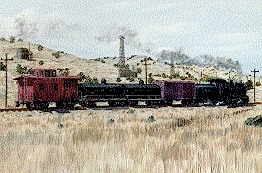 "Carrying Black Gold to market" This
picture depicts Engine 111 of the Pacific Coast Railway
heading south with the Careaga Ranch to the left carrying crude oil
from the wells near Orcutt. Engine Number
111 was acquired from the Nevada-California-Oregon R.R. in 1928, sold
to Oahu Railway in Hawaii in January of 1942, and eventually scrapped
at Honolulu in 1946.
Other
(semi)historical
happenings on what became the Careaga Ranch:
To the northeast of where Bicknell was and southeast of
today's
town of
Orcutt
is flat topped Solomon Peak, distinctively crowned with its array of
radio and cell phone antennas. If you will lend me an ear,
I'll
tell you legend of El Zorro de Santa
Maria.In local lore, Solomon Peak was the 1850’s hideout of the infamous bandito, Salomon Pico (notice the clever use of like-sounding names). Salomon Pico is widely believed to have been the inspiration for Johnston McCulley’s Zorro written in 1919. Like Zorro of the romantic tales, Salomon wore a mask, shared his bounty with his countrymen and often marked his victims so they would remember him - if they lived to tell about it. Rather than marking them with a “Z” though, our man cut off an ear (ouch!) with his dull, rusty old sword. That's why the oldtimers living in Orcutt have always earmarked this hill as a rather eerie place. The story is told that Señor Pico was a well-to-do land owner living with his wife on his rancho up near Sutter's Mill. He was forced off his land and his wife (Juana Vasquez) was fatally injured in some kind of dispute with gold miners sometime after 1849. After his loss, he moved to the Santa Maria Valley and went into business selling cattle and horses by day, but by night, he would rob men traveling along El Camino Real who were here to buy cattle to feed the men working the gold fields. His banditry, so the story goes, was a political act of retribution since he was wealthy and didn't need the money. Pico may or may not have been a real person and may or may not have buried gold on or near Solomon Peak, but over the years a lot of people have dug holes up there looking for the legendary stashes. To the best of my knowledge, nobody has ever found so much as a penny, but several years ago I did find an old 45-70 brass cartridge by sheer luck way out in the hills. Perhaps we'll never know if Salomon Pico ever really existed, but it seems that the hills around Solomon Peak and Graciosa Ridge really were infested with bandits in the mid to late 1800s. In those days, the ranchers would herd their cattle out to the shore near Guadalupe Beach/Point Sal so that they could swim them in the surf out to waiting cattle ships. The ships would them take the cattle to markets in San Francisco and Los Angeles. Indeed, the reason our area is called "The Gold Coast" is not because any gold was ever found here, but because of the golden colored wheat that was formerly grown in abundance here (*A4). Like the cattle, the wheat was transported to markets by ships that were loaded from small barges or lighters that operated from the shores of Guadalupe Beach out to the larger ships in deep water. 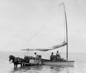 Loading a lighter from the beach. After disposing of their cattle and grain to the ships, after having a few drinks at the Far Western Tavern there in Guadalupe and on their way back home, the rancher's pockets would be lined with gold coins making them tempting targets for the local banditos hanging out in what is today's Orcutt Hills. There are many stories of marvelous adventures and great good times, both old and recent, that have occurred on the lands that were once the old Careaga Ranch, but they will have to wait for another time. A wealth of interesting historical information regarding the Santa Maria Valley may be found at the Santa Maria Historical Museum at 616 S. Broadway in beautiful downtown Santa Maria. The
End
Having
arrived this far,
obviously you have a superior attention span and reading ability that
far exceeds that of the
Were you entertained or
was this article just awful?majority of web users. I highly value the opinion of people such as yourself, so I ask you to briefly tell me: Please visit my guest book and briefly tell me before you leave my website. If you like my web page, tell your friends, if you don't like my web page, tell me. If you have any detailed comments, questions, complaints or suggestions, I would be grateful if you would please E-mail me directly  Shooting Sports Selection Page If you are interested in early radio and vacuum tube radio technology, perhaps you would like to read something from my
My website contains lots of other stories and things, so Vintage Radio Selection Page Please visit my Home Page for more exciting adventures The Union Oil Company and Careaga oil (*A1)
Since the Union Oil
Company of California is so important to this
region and has left behind things that endure to this day, I'd like to
say a
brief word about it. In 1890, oilmen from Pennsylvania
by the names of Stewart and
Hardison combined their assets with those of Thomas Bard, a prominent
California
businessman, to form the Union Oil Company of California. The company
was incorporated on October 17, 1890, in the small town of Santa Paula,
located about 100 miles northwest of Los
Angeles. It grew rapidly and by 1907 the Union Oil Company
controlled 75% of all
the oil activity in this area,
but many smaller operators, including the Western Union Oil
Company, were active too and most had business links to Union
Oil.
Western Union Oil continued in business until its leases were
bought by Shell Oil in the late 1940s.

Lyman
Stewart
By the way, in a smart move, Union Oil hired William W. Orcutt as their geologist in 1899 and it was Orcutt who revolutionized oil exploration by creating the world's first geologic maps of the oil bearing structures on the Careaga Ranch. Up until this time oil wells were drilled by "wildcatters" who didn't know a lick about geology and who would sink a hole in the ground without understanding what they were drilling into. Orcutt's mapping of underground geologic structures changed all that and made oil exploration into a science. It might be interesting to note that the oil of our region is derived from the famous Monterey Formation that was laid down in a deep ocean basin that existed here about 20 million years ago during the Miocene. For millions of years, the Santa Maria Basin collected thick layers of tiny, single celled, diatom plants which, when they died and sank, took their stored nutrients with them to the bottom. These nutrients later converted into oil, the oil concentrated and got trapped when the layers folded and started pushing up out of the sea about 3 and a half million years ago. 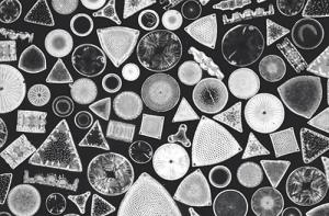 Single celled diatoms under the microscope. As mentioned earlier, the oil around here is very high in asphalt, which makes it good for road material and for manufacturing all kinds of petrochemicals including plastics. The fact is, our oil is not particularly valuable because it is very poor in paraffins (meaning that there's very little lubricating oil in it), it is very thick and hard to pump out and it is very "sour" with a lot of poisonous hydrogen sulphide gas mixed in it. The most valuable oil is the famous "light, sweet, crude" rich in paraffins from the Middle East, but our "heavy, sour crude" rich in asphalt is not what the oil market wants. To make matters worse, there is a lot of salt water (trapped sea water when the sediments were laid down) that comes up with the oil and that has to be separated out and disposed of. No, back in "the good old days," our local oil industry created a lot of wealth, a lot of local manufacturing and a lot of jobs, but it day is done. (Please
use your "back button" to return to the story)
.Solvang
(*A2) The name Solvang means "sunny fields" and compared to
the
gloomy weather of Denmark, these fields must have appeared sunny
indeed. (Please
use your "back button" to return to the story)
. The
difference between an adventure and a disaster
(*A3) There's an old saying John made up a while
back: "the
only
difference between an adventure and a disaster is that in an adventure,
nobody gets killed." It appears that few if any of these
stagecoach
journeys ended in disaster, but certainly they were
adventures. Many people living today would consider such
adventures as "nasty things that make you late for dinner" but some of
us yearn of them nevertheless.(Please
use your "back button" to return to the story)
. Why
Santa Maria's streets are so wide
(*A4) By the way, the reason
why Main Street in Santa Maria was laid out so
wide
(for a town of that era) is because the early town planners wanted a
main street wide enough for the huge grain wagons, pulled by a team of
20 mules, to be able to turn around right in the middle of the street.
 The new town of Grangerville, later Central City, later Santa Maria needed wide streets to accommodate the big grain wagons. Of course, the downside of having such wide streets is that Santa Maria has always been too open to the strong, cold winds that blow so hard through the unsheltered downtown, thus discouraging pedestrians and shopping. (Please
use your "back button" to return to the story or read John's Rant No. 1
directly below)
John's
Rant No. 1 (about
the Santa Maria Mall)
In
the 1970s an ill-starred
attempt was made to
overcome the problem of a town that was too open to the elements, so,
in what I think was an undemocratic political maneuver and certainly
against the ardent advice and wishes of wiser
citizens, the historic heart of
Santa Maria was ruthlessly torn down and replaced with the truly
disastrous Santa
Maria Downtown
Mall. (A highly opinionated philippic that you are under no obligation to agree with): Few will disagree that The Mall has been an economic failure from its very beginning to the present day (although it can be argued that the recent changes are an improvement and business may pick up). If that wasn't bad enough, tearing down the old downtown quickly put all the indigenous merchants out of business as rents skyrocketed and "mall stores" came in and undercut them. Even worse than that, tearing down the heart of town has sadly removed from our town almost all of its local history, culture and character without so much as donating a square inch of space or a nickel of money to anything of a civic nature. This Mall has robbed us of our history, but has done precious little to enrich our community except to provide minimum wage clerking jobs and shop space for stores who's out of town owners and executives might as well live in Cambodia for all they care about our community. To this day, our struggling little Orchestra has no place to perform except in halls belonging to one of the Fundamentalist Churches. We have no civic concert hall to attract famous performing artists and our tiny museums occupy otherwise abandoned houses and buildings. On the other hand, there has always been plenty of empty space in The Mall as one store after another goes broke and leaves, but never any room for anything of civic or cultural value. I do admit that, despite all the clannishness, selfishness and the lack of community spirit & pride that the wealthy and influential of this town have always been so justly infamous for, our town recently built a beautiful big library. This library is worthy in every way of our town and something I, for one, am immensely proud of. (Please
use your "back button" to return to the story)
John's
Rant No. 2 (about
"gritty" Santa Maria)
It's hard to imagine how much wealth
has been
pulled out of the
ground since Careaga No. 3 came in. So many people were made
wealthy
by Careaga oil and the oil from the huge strikes found at nearby Gato
Ridge, but now there's nothing to see of it except
scarred hills and abandoned wells and rusty old junk scattered out
there on the old oilfields. (and strictly his opinion that you are under no obligation to agree with): Certainly there is precious little to be seen of this great wealth in works of art, architecture, cultural artifacts or institutions and monuments anywhere in the Santa Maria Valley. Businessmen and laborers came in to our area, made their money and got the hell out as soon as they could (or hoped to anyway), leaving behind scars and trash for other generations and people to deal with. I mean, even the Careaga brothers got out as soon as they became wealthy. This, in a nutshell, is pretty much the history of the Santa Maria Valley which is only now starting to change. This is perhaps the primary reason why the Santa Maria Valley has always been considered an "ugly, gritty, working-class" area without the culture, the fine architecture and the lovely cachet of "beautiful" places like Santa Barbara, San Luis Obispo or the Santa Ynez Valley: people have always come here to "make a pile," but not to "put down roots" with only a few actually wanting to make this their home. Few people wanting to make this their home and even fewer people who have the wealth ( since the truly wealthy go to live somewhere else) and civic pride in the community to make Santa Maria and its surroundings as beautiful as Santa Barbara or San Luis Obispo. Things may change though. As people of taste and intelligence discover the unexcelled climate, the rugged beauty of our scenery, our lack of crowding and urban pollution and our easy proximity to everything good about California and, yes, as our area evolves in terms of culture, infrastructure and architecture, perhaps opinions about Santa Maria and its adjacent communities will change. (Please
use your "back button" to return to the story)
|