|
AN AMATEUR GEOLOGY
ROAD TRIP
My travels through the Colorado Plateau of southern Utah and northern Arizona. by John Fuhring June, 2010 Page 1
As mentioned in the introduction, I didn't start my trip
until early June although I had meant to leave as early as April.
Finally I had all my stuff together, the horses arranged for and
my truck loaded with my Mt. bike, food and camping gear. Despite
the cost of fuel, I decided to take my long-bed, 3/4 ton, 4WD pickup
with its huge wheels and high ground clearance. With my pickup
truck, I'd be undaunted regardless of the condition of the back
roads and I'd have room for every piece of gear I could possible think
of bringing (some of which I didn't even use). Here is a link to
the list of all the junk I brought with a star by the items that
prooved to be especially useful. The Mt. bike wasn't as useful as
it could have been, but it did provide me some nice exercise and it was
fun to ride around the camps in the early eveining hours when I would
otherwise have nothing to do. One of the dumbest things I brought
was a DVD player, but no DVDs to watch and there were times I really
wanted a little entertainment.
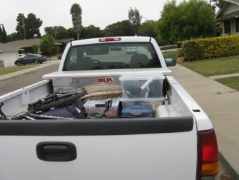 The pickup loaded and about to drive away. An essential
part of 'Plan A' was to get up really early, load the pickup with
pre-selected and packed items (all arranged in my living room so I
wouldn't forget anything) and be on the road by 6 AM. Well, it
wasn't until after 8 AM that I was finally ready to go. Then more
wasted time as I tried to get my handheld GPS to talk to my laptop -
until I finally realized that I knew the way to the Colorado Plateau
better than the back of my hand and didn't need the GPS. Finally
I crossed the Santa Maria River and on to Highway 166 going east.
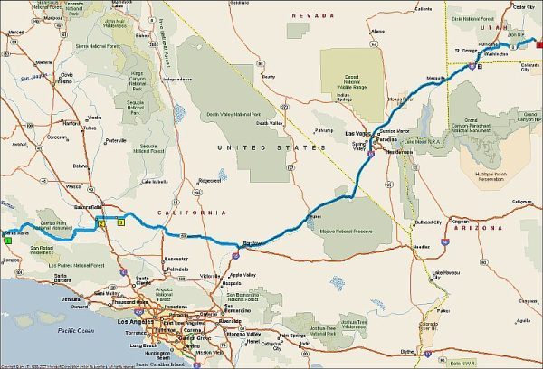 Highway Map Day 1. I got to the town of Tehapachi and it was pleasantly cool up there. I passed the outcrop of ancient paleozoic limestone that had formed in a warm, quiet sea long before the granites below them and are now a "roof pendant" on top of the mesozoic era granites. Nearby is the huge cement plant that takes those carbonate rocks that have lain there all those hundreds of millions of years, all through the evolution of a line of amphibians into reptiles, a line of reptiles into mammals, a line of mammals into primates and a line of primates into me. Those ancient carbonates from a tropic sea so long ago were there when the first fire was lit by our Australopithicus ancestor, when the first pyramid was built, when Julius Ceasar was stabbed and when the Battle of Gettyesburg was fought, but now they are being dug up and turned into cement for the buildings of Los Angeles. 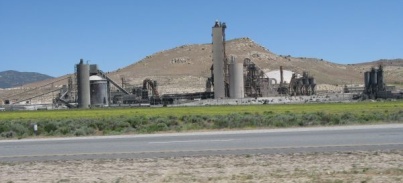 Cement Plant at Tehapachi |